

a cost-effective, fully cloud-based Intranet GIS for your whole organisation
Overview
XMAP Cloud GIS includes workflow-driven tools and a wealth of mapping data to help users visualise, analyse and share spatial information. The software has self-service administration tools to ensure data flows in a structured and secure way.
The service is updated on a weekly basis with new tools and features to cover a range of use-cases. Where bespoke customisation is needed, Geoxphere can create dedicated tools and workflows to meet the needs of your team.
The service is updated on a weekly basis with new tools and features to cover a range of use-cases. Where bespoke customisation is needed, Geoxphere can create dedicated tools and workflows to meet the needs of your team.
Responsive Design
The touch-enabled interface works different screen sizes so users can access data and tools wherever they are.
Single Sign-on
Cloud GIS can be deployed with in-built User Management or through utilising a Single Sign On (SSO) manager, giving flexibility on or off-site.
Unlimited Usage
No restrictions on usage within an organisation, and in some cases unlimited user accounts (in Local Authorities, for example).
Web accessibility
We conduct regular accessibility reviews to make the user interface and mapping as usable as possible. We take WCAG standards as our guide.
Encrypted and Secure
All communications are encrypted and the system holds up to rigorous penetration testing. This allows high security data to be hosted confidently.
Rapid deployment
We do all the hard work setting up the account with tools to easily switch from other well-known services. So you can get started in a matter of hours.
Service Benefits
Working from Home
Accessed from any web browser on an internet-connected device. This allows staff to access XMAP without VPNs or Thin-Client connections.
Save time collaborating
Share datasets between teams automatically through group profiles. This saves time and effort copying information between departments.
Single Source of Truth
With the master copy of each dataset hosted on XMAP, users can trust that the data is correct and up-to-date. Reducing errors and uncertainty.
No Supplier Lock-in
Your GIS supplier should not own your database. We host your data in open-source technology and we support independent databases.
Reduce IT Dependence
You don't need to think about architecture when subscribing to XMAP. We handle everything on our highly resilient servers.
Unrivalled Customer Care
When you subscribe to our services, you get the whole team. We co-own your problems and help you solve them.
Integration with QGIS
Data layers stored in XMAP can be viewed and edited in QGIS.
This allows a layer to be viewed in XMAP and QGIS at the same time, giving advanced GIS users the capabilities of QGIS with the hosting and sharing of XMAP.
See it in action below where a user edits a layer in XMAP and QGIS simultaneously.
This allows a layer to be viewed in XMAP and QGIS at the same time, giving advanced GIS users the capabilities of QGIS with the hosting and sharing of XMAP.
See it in action below where a user edits a layer in XMAP and QGIS simultaneously.
Constraints Checker
Don't spend hours trawling through GIS layers. Let the XMAP Constraints Checker work for you.
Create a template defining the GIS layers you need to search on. Then draw an area on the map and the Constraints Checker will search for all map objects within that area.
Re-use the template again and again. Great for repeatable tasks where consistency and accuracy is essential.
Create a template defining the GIS layers you need to search on. Then draw an area on the map and the Constraints Checker will search for all map objects within that area.
Re-use the template again and again. Great for repeatable tasks where consistency and accuracy is essential.
Runs in ~30 seconds, depending on your template
Configurable, profesionnal PDF outputs branded to your organisation
Set buffers to return objects that are nearby as well as within the search
Repeatable and consistent search and reporting for your whole organisation
Addressing and LLPG
Address data is key to many business and Local Authority functions, so we don't just treat it like any other layer.
Intuitive visualisation, nightly synchronisation, UPRN lookup and advanced deep-dive searching gives users everything they need to find a location fast.
Intuitive visualisation, nightly synchronisation, UPRN lookup and advanced deep-dive searching gives users everything they need to find a location fast.
XMAP Collect (Mobile Data Collection) - BETA
XMAP can be used on a mobile or tablet to view and edit data.
Instead of uploading and downloading data to perform a survey, XMAP uses your internet connection to get the latest information direct from the XMAP database.
XMAP displays your GPS position using the geolocation capability of your mobile or tablet.
Instead of uploading and downloading data to perform a survey, XMAP uses your internet connection to get the latest information direct from the XMAP database.
XMAP displays your GPS position using the geolocation capability of your mobile or tablet.
Structured data editing using date and drop-down fields
Have multiple users editing the same dataset at the same time
Take photos and attach them to map objects, stored directly to XMAP
Quickly find, assess and update official records, directly to XMAP
Never lose data from a survey. It's automatically saved in XMAP
Accessed through a web browser, so no apps to install and manage
Premium Ordnance Survey data with OS API
This is big news for our UK subscribers! Use our access to premium Ordnance Survey mapping, including the OS MasterMap Topography Layer and only pay for what you view.
Automate GIS Workflows: Batch Print
The Batch Print tool allows you to automate the production of maps based on a query on your data.
For example, "print out all planning applications that were rejected". You don't want to find these and print them manually, so use this handy automation to do the job for you.
For example, "print out all planning applications that were rejected". You don't want to find these and print them manually, so use this handy automation to do the job for you.
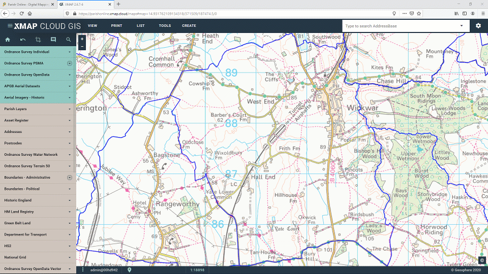
Mapping Features
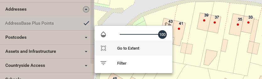
The Layer Control in the side-bar makes it quick and easy to find and enable different datasets. It has expandable collections so themes of layers can be easily grouped. It has built-in options such as; Zoom to Extent, Add Feature, Slide Transparency, and Filter.
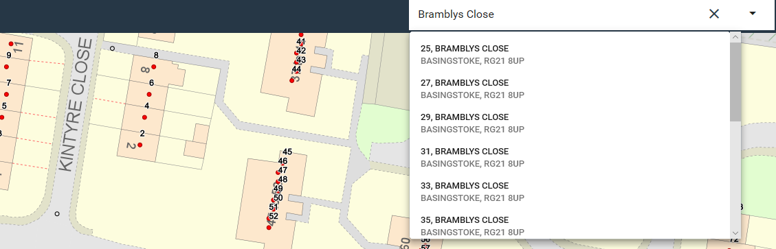
The search bar gives users a quick way to get to a location using a search term. This can be configured to search datasbases such as OS AddressBase or LLPG as well as other global search databases. Selecting an address zooms the user straight to that location.
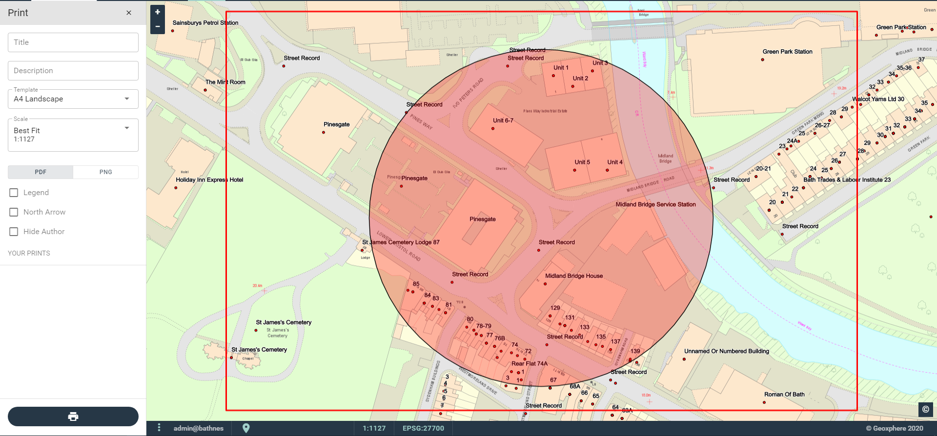
The Print tool allows users to create professional, branded, accurate documents ready for distribution or physical printing. It allows the user to set the location, scale, legend, paper size and layout.
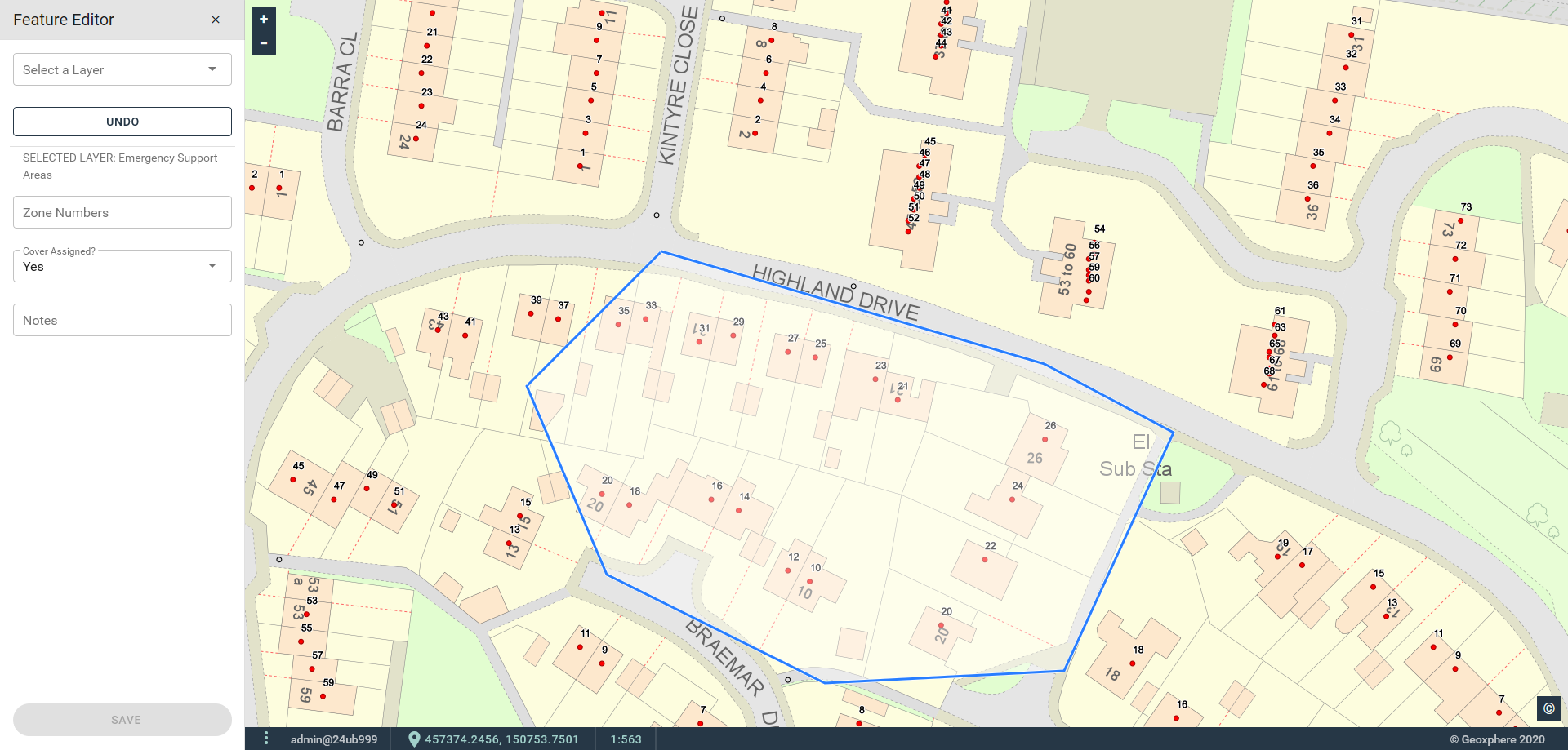
Editing of layers can be enabled for any layer in XMAP. This is controlled by the administration tools to ensure data integrity. Points, lines and polygons can be added, edited or deleted to conform to set attribution and styling criteria. Any edits have a data trail including user and time.
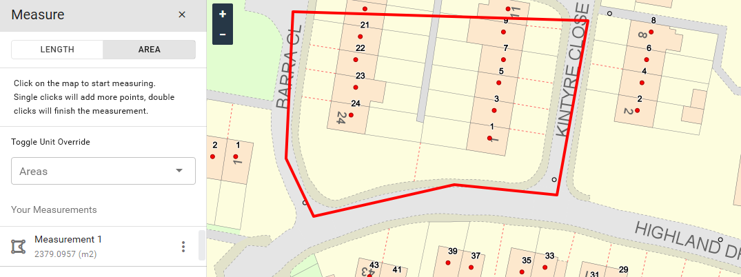
A free-hand distance and area measurement tool that displays the results in the user’s unit preference.
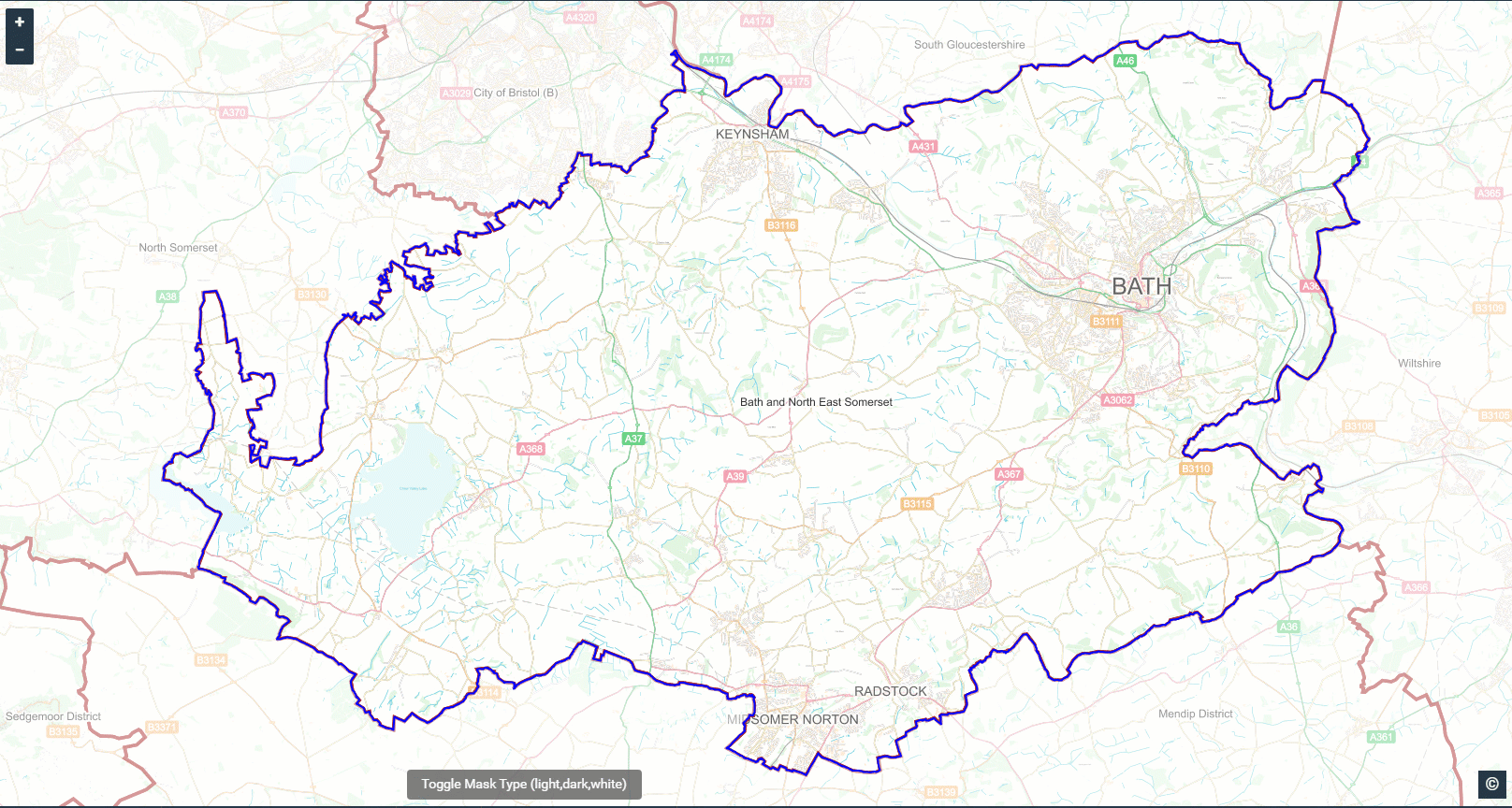
Focus the map on the geographic extent that’s important to your team. There are three style options; transparent white, transparent black and solid white.
Advanced Address Search. This full-screen view gives a deep-dive into either AddressBase or your LLPG. Users can search and filter by postcode, town, LPI or building type. Results can be shown on the map or exported to CSV.
List View Search. This spreadsheet-style view of a map layer has filtering and sorting features to easily find content. Entries can be selected and found on the map or exported to CSV.
Data Extract. A spatial search tool that finds all map objects found within a user-defined area. This works on a single layer at a time. It has filtering capabilities so only returns map objects of a particular type. Useful for extracting residential addresses, for example.
Bookmarks. Used for recalling a specific location and set of enabled layers. This is useful for taking users back to specific project sites without having to re-enable layers manually.
Attachments. If permissions allow, documents can be uploaded and stored against a point, line or polygon feature.
Coordinate Finder. A lookup tool for navigating to specific coordinates in British National Grid or Latitude/Longitude.
Administration Features
Data Sync - Scheduled. XMAP Data Sync is a small executable program that, when run, takes the contents of a folder of shapefiles and ingests them into XMAP. This can be run on a nightly schedule and any duplicate layers found are overwritten on XMAP. This is a quick way to ingest data when starting to use XMAP, and a handy ‘set-and-forget’ tool for ongoing maintenance.
Data Sync – LLPG and IDOX. For UK Local Authorities, copies of LLPG can be uploaded into XMAP to be used as a search tool. The LLPG is automatically generated as a map layer as well. If a schedule is set to export IDOX data (or any similar application), this data can be loaded into XMAP.
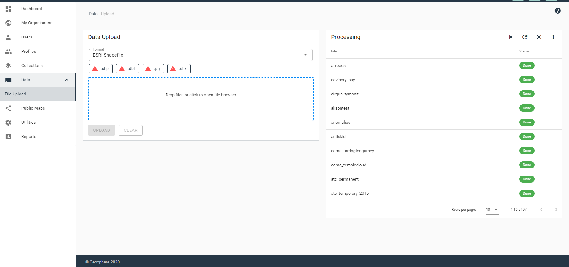
Data Sync – Drag and Drop. Shapefiles can be loaded through the Admin Panel at any time using the drag-and-drop interface. A report for all loaded, pending, completed and failed layers are shown so action can be taken, if necessary.
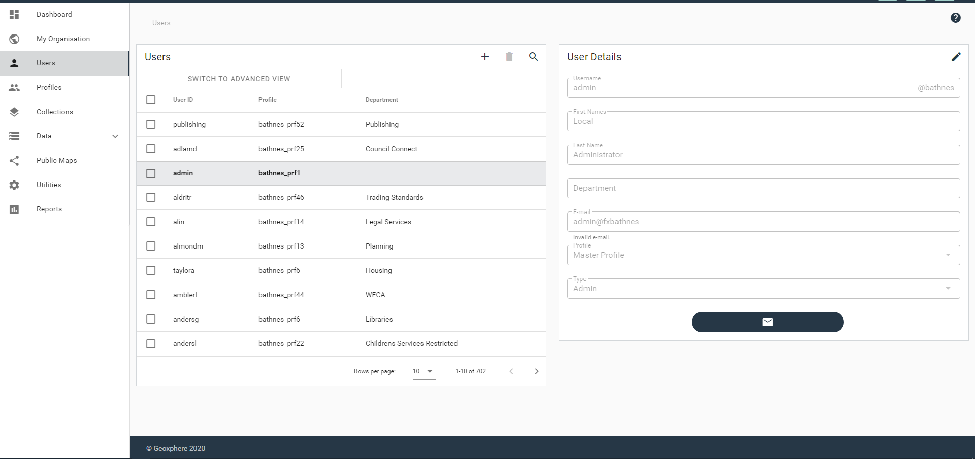
This allows you to create, edit and delete user accounts. It has batch options including changing profiles and sending password reset emails.
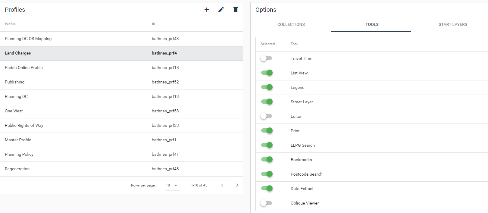
Profiles consist of collections of layers and sets of tools. A variety of profiles are usually configured to cater for the needs of different departments. Through Profiles you can restrict access to specific collections of layers.
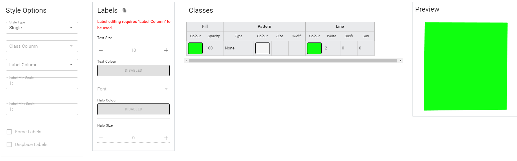
Options for styling the layers with a range of symbology, fill styles and labelling. Layers can be styled with a single style or by classes, so features will change their colour depending on information stored within them. This allows dynamic and engaging maps to be produced. XMAP includes a vast array of symbols covering many themes, including environment, society, civil security and asset management.
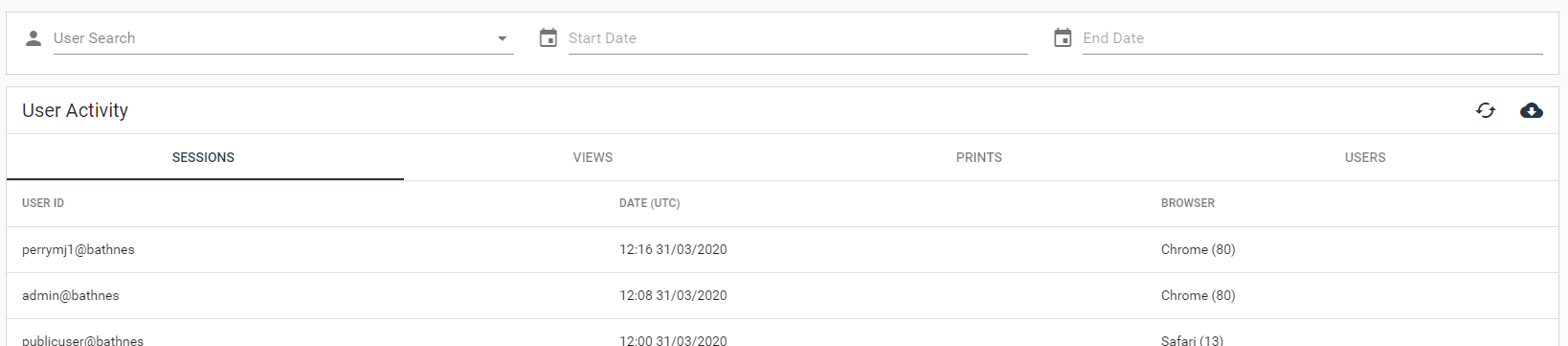
Displays user login times, browsers used, layers displayed and printouts produced. Can be set to specific time or user limits. This feature gives administrators insight into how XMAP is used across an organisation.
Branding Manager. This allows you to configure the logos used on-screen and in the print templates. It also has a default language option.
Collection Manager. This allows you to group layers into collections (or sometimes called Folders) to organise layers into themes of information. This makes them easier to find in the Layer Control.
Data Layer Manager. This allows you to control the name, description, copyright, styling, viewing permissions, editing permissions and publishing settings.
Data Layer Creator. Create new Map Layers directly within XMAP or add external WMS feeds. Permissions to create layers can be given to other users as required.
Copyright Manager. Gives a list of available copyrights to apply to layers, and allows the creation of your own.
Data Features
XMAP includes a fully-maintained Ordnance Survey stack with three style options; standard, greyscale (black & white) and white (for viewing on aerial photography). If you’re only intending on using XMAP Cloud GIS and XMAP Public Map then you don’t need to purchase additional web map services.
We maintain over 250 data layers from a variety of government agencies and include them in your XMAP account. This means you get the benefit of having the data for the whole country, and you don’t have to keep them updated yourself. Sources include:
- Ordnance Survey
- Environment Agency
- HM Land Registry
- Natural England
- Department for Transport
- Historic England
- Natural Resources Wales
- CADW
- DEFRA
- Coal Authority
We include base mapping, satellite imagery and a range of global datasets in any XMAP account to provide a great starting point for using digital mapping.
If specific datasets are required for your work then our team can source them and include them in your account.
Take advantage of the power of cloud-based architecture to share live data to Local Councils with zero effort. XMAP can be configured so that certain collections can be shared live to Parish Online. This means all town, parish and community councils in your area get the benefit of seeing your data in a controlled way.
XMAP utilises modern, open, cloud databases
Is your data locked away in an expensive proprietary database? That's got to change!
With XMAP, our entire ecosystem is based on open-source database technology. As an XMAP subscriber you can utilise our pre-built database, or we can create an independent cloud-based database for you.
With XMAP, our entire ecosystem is based on open-source database technology. As an XMAP subscriber you can utilise our pre-built database, or we can create an independent cloud-based database for you.
Case Studies


Pricing
All XMAP Suite services are charged as a subscription service with no capital investment.
We have a range of pricing models and offer flexibility to make sure our services are great value for money.
We have a range of pricing models and offer flexibility to make sure our services are great value for money.
UK Local Government
G-Cloud
- Verified G-Cloud framework service
- No tender process necessary
- Setup in less than a day
- Multi-year discounts
Commercial
£100per month
- For up to 5 users
- Premium OS mapping credit included
- Volume discounts
- Multi-year discounts
Commercial
Bespoke
- Fixed annual subscription
- Unlimited usage and users
- Monthly, quarterly or annual payment options
- Multi-year discounts
Not sure what to choose? Don't worry, get in touch and we can find a model that's right for you.